There is an app for pretty much most things nowadays and green laning is no different. Using an app is just a replacement for the old school map method and I don’t blame you. It is much more user friendly way of navigating in modern times.
ViewRanger is the best app for green laning, with the ability to import routes and save your own rides so you can build up a portfolio of green lanes to ride. The paid addon for OS Maps is a great option that makes this app the only one you need.
There are a couple of different apps you can consider but in my opinion view ranger is the best although lets touch upon the others too so you can see what is what.
Why ViewRanger?
There are a few things I like about viewranger that make it stand out for me.
- you can sync routes from the website to you phone app
- download other peoples routes
- its not expensive – can use for free
- you can intergrate OS maps
The viewranger website can be found at viewranger.com where you are able to sign up for an account. There is no charge to do this and it means you can save routes so you may as well do it.
Once logged in you can select to search for a type of route and because this isn’t a resource made for the green laning community there are different types of routes, such as hiking, running, cycling and even sailing.
They do however have a category for green laning which is great.
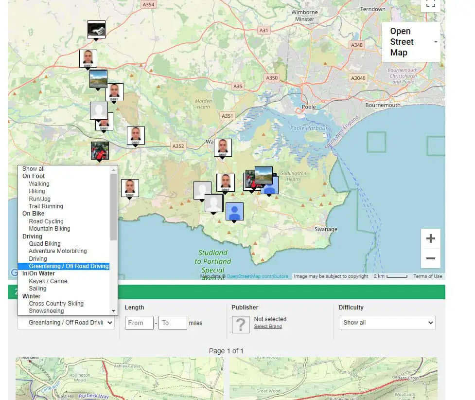
When you select the type of route the map will load any routes found in the area visible. That means if you are zoomed right in on say a field then it is unlikely to show anything. If you don’t see any routes then try and zoom out.
Equally if you are zoomed out to far it will summarize the amount of routes with a number without showing each individual route, so zoom in a little for more details.
In this area on the map above you can see 29 different routes that have been saved from other people which is awesome as you don’t have to search for these new routes yourself.
You may wish to double check them against an OS Map and TRO’s in your area to make sure you can legally ride there. (If you don’t know what TRO’s are then read my post here – Is Green Laning Legal and Where To Ride)
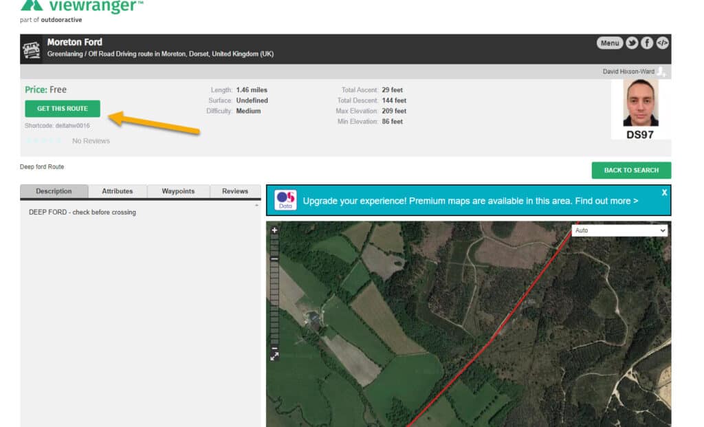
Now once you have a found a route you like you have the option click the ‘Get This Route’ button to download the routes to your account. You will also see info about the route like milage, any notes and reviews. There will also be a price tag, although many routes uploaded via individuals are free.
Once downloaded the route will sync to your mobile after you have installed the and given it permission to sync with your website account.
You can do all of this from mobile but personally I much prefer doing it on the website when planning a green lane ride, because it is normal for me to do routes combined with roads to reach another green lane to make up a days ride out.
Other Perks To ViewRanger That Are Worth Mentioning.
If you are new to Green Laning then you may not be aware of the Trail Riders Fellowship, or TRF as known by most. This organisation is a members based organisation that campaigns against the closures of green lanes in the UK as well as providing a hub to find other like minded people and info about the topic. They also arrange trail riding trips and all for a very reasonable £52 per year, at the time of writting.
A few years ago, im not sure exactly when, they linked up with viewranger to be able to provide an app for offroading. Thats how they put it, but in essence it is just the ViewRanger app.
You can get access to your local TRF routes and download them to your routes, but this isn’t too different from scanning your local area as explained above.
Another thing that I really like with the ViewRanger is the ability to add OS Maps for £25 a year.
I’ll explain about OS Maps in a moment but I like the fact you can get it on the same app and the pricing seems reasonable.
ViewRange App Conclusion
Why it’s the best green laning in summary:
- Easy functionality between computer and phone app
- Ability to add OS Maps
- Find routes to ride
- Create and save your own routes
- Very cost effective
OS Map App For Green Laning
OS stands for Ordnance Survey and they are probably the most recognised mapping company in the UK and have been going since 1791.
Many people would of seen the old school physical maps and they are still available to buy today. But as with all things modern, they are also online.
Similar to other apps, you can view on your desktop or mobile app and sync between devices. You can also plot and save routes as well as downloading other people routes.
The reason it isn’t top dog for me is the fact you pay for a subscription for some of the features where you can get the same free in apps like viewranger.
Couple that with the premium subscription being the same price as when you buy it with viewrange, then you may as well go with viewranger and have 2 in 1.
Here’s a quick breakdown of what is included in the free and paid versions.
(info source: https://shop.ordnancesurvey.co.uk/apps/os-maps/)
| Free Version | Paid Version | |
| Standard, Green space Maps | ✓ | ✓ |
| Find Routes | ✓ | ✓ |
| Plan Routes | ✓ | ✓ |
| Printing | ||
| OS Explorer, OS Landranger maps | ✓ | |
| Aerial 3D | ||
| Use Maps Offline | ✓ | |
| Record Routes | ✓ | ✓ |
| Augmented Reality | ✓ | |
| Use Codes From Paper Maps | ✓ | ✓ |
| Access Premium Routes | ✓ | |
| Snap To Path Route Planning | ||
| A3 Printing | ||
| Aerial View | ✓ | ✓ |
| Night Map | ✓ | ✓ |
| Greenspace Map | ✓ | ✓ |
| 250K Road Map | ||
| Places Of Interest | ✓ | ✓ |
| Import GPX Files | ✓ | ✓ |
| Export GPX Files | ✓ | |
| Personal Preferences | ✓ | ✓ |
Items with no ticks are because it is available on the subscription but web based only, not on the app.
Garmin Explore App
The Garmin App in short is comparable to other apps although best suited to Garmin devices and they can be expensive.
A number of people recommend the Garmin Montana 600 but at £500 these are not my favoured solution.
The Garmin Explore App is compatible as a stand alone app but the reviews on the play store do not look great, with regular complaints about conneectivity issues and login problems.
I will say I have never personally tried the Garmin to my opinion is limited. If you already have a Garmin device then worth a try.